By Associated Press’s Tammy Webber
Salt ponds that were formed over a century ago in San Francisco Bay are turning back into marshes. Many beaches damaged by Superstorm Sandy were restored along the shores of New York and New Jersey. A restored spit of land in Alabama is protecting a historic town and serving as a refuge for wildlife.
Coastal communities around the country are stepping up their efforts to combat the rising seas, bigger storm surges, and higher tides that are eroding coasts, sending seawater farther inland, and endangering communities and ecosystems.
This month, Louisiana officials shelved a $3 billion project due to fishing sector complaints and concerns about escalating costs, bringing attention to the need for coastal restoration. By redirecting sediment-laden water from the Mississippi River, the Mid-Barataria project was expected to restore over 20 square miles (32 square kilometers) of land over roughly 50 years.
Barrier islands, saltwater marshes, shellfish reefs, and other natural features that offered protection before being lost or damaged by development are among the several other initiatives that are still underway in Louisiana and around the nation. In order to safeguard regions that do not have sufficient natural protection, communities are also constructing levees, berms, and flood barriers.
According to scientists, the urgency of the job has increased as climate change results in more powerful and severe storms and sea level rise that endangers tens of millions of people and hundreds of communities.
Doug George, a geologist oceanographer at the National Oceanic and Atmospheric Administration, stated that the sooner we can strengthen these coastlines, the better.
Gulf Coast
The hurricane-prone Gulf Coast is arguably the most vulnerable area in the United States. The U.S. Geological Survey reports that over the previous century, Louisiana alone has lost more coastline than any other state, totaling more than 2,000 square miles (5,180 square kilometers).
Historically, shore-buffering marshes were nourished and land was rebuilt by silt deposited by the Mississippi and other rivers. However, the building of levees and channels, among other developments, interfered with that role.
The risks were increased in 2005 when Hurricane Katrina and Hurricane Rita both broke through levees and flood walls, flooding 80% of New Orleans and killing nearly 1,400 people.
In order to reduce storm surge threats and stop land loss, the state then established the Coastal Protection and Restoration Authority.
According to the authority, the majority of the nearly $18 billion spent over the previous 20 years went toward strengthening levees, flood barriers, and other structures.
Numerous other projects, such as reestablishing river flow in places that haven’t had it for years and reestablishing marshes and other habitat using material excavated from streams, are finished, planned, or in progress.
According to Katie Freer-Leonards, who is in charge of creating the state’s 2029 coastal master plan, Louisiana will pump in sand to aid in the reconstruction of the barrier island chain known as the Chandeleur Islands. This will help to reduce storm surges and benefit sea turtles and other animals.
According to project manager Brad Miller, the authority is excavating a canal to let water and sediment from the Mississippi River enter a portion of the Maurepas Swamp, a forested wetland that is about 218 square miles in size and northwest of New Orleans. The wetland has been dying for more than a century due to levees.
Additionally, thousands of acres of sinking marshes have been nourished and their levels raised by pumping sediment that has been dredged from other locations.
Other states are experiencing the same thing.
A fishing community constructed in the late 1700s near Bayou La Batre, Alabama Offshore, the Nature Conservancy constructed breakwaters, pumped silt in, and created ridges that are now covered in plant. According to Judy Haner, director of coastal programs for the Alabama Nature Conservancy, that resulted in a speed bump that has assisted in preventing erosion in the town.
Along with building miles of oyster reefs, the conservancy and others are also purchasing land far from the coast to enable habitats to relocate when seawater encroaches.
Watch the video of Alabama’s beach restoration project before and after.
According to Denise Reed, a research scientist working on Louisiana’s coastal master plan, while such initiatives won’t stop all land losses, taken as a whole, they could have a significant impact. We might be able to purchase some time.
Pacific Coast
Communities on the West Coast that are susceptible to sea level rise may also see increased flooding as a result of increasingly powerful atmospheric rivers that quickly drop massive amounts of rain and carry water vapor from the ocean.
For the sake of habitat and coastal preservation, tidal marshes and estuaries that were drained for industry and agriculture are being restored along the whole coast.
When planning started around 20 years ago to restore marshes around the south end of San Francisco Bay that had been lost when ponds were built to harvest sea salt, habitat restoration—rather than climate change—was the main factor.
However, we’re discovering that marshes absorb wave energy, storm surge, and the intensity of high tides as silt naturally fills ponds and marsh plants reappear, said Dave Halsing, executive project manager at the California State Coastal Conservancy.
This helps safeguard everything behind them, such as sea walls and land that may otherwise be flooded or washed away, including some of the priciest real estate in California, which is located close to Silicon Valley.
Additionally, there are ongoing projects in Hawaii and Alaska where locals are restoring old rocky enclosures that were built to trap fish but also serve as storm surge protection.
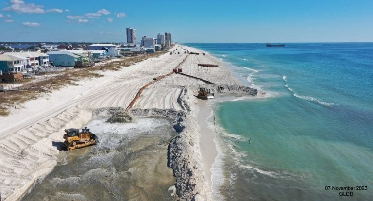
Atlantic Coast
Communities are still repairing natural barriers and erecting other protective infrastructure thirteen years after Superstorm Sandy flooded the Atlantic coast.
In the fall of 2012, Sandy started out as a fairly typical hurricane before combining with other storms to form a record-breaking 1,000 miles and force massive volumes of ocean water into coastal cities.
According to Donald E. Cresitello, a coastal engineer and senior coastal planner for the U.S. Army Corps of Engineers, sea levels in some places could increase by up to three feet in the next 50 years, making future storm surges an even bigger threat.
According to Cresitello, the Corps is now focusing on regions further inland that are more susceptible to stronger storm surges after rebuilding beaches, dunes, and man-made buildings from Massachusetts to Virginia.
According to him, depending on the storm, a storm surge may just ride up a river that is approaching the coast.
According to George, the NOAA scientist, the U.S. economy depends on the protection of coastal areas because a staggering portion of the country’s population lives and works there. However, he added, it’s equally critical to protect generations’ worth of culture.
According to George, “it’s a whole way of life when you think about why people should care.”
This article was contributed to by Stephen Smith, a video journalist for the Associated Press.
Several private foundations provide funding for the Associated Press’s coverage of the environment and climate. All content is the exclusive responsibility of AP. Visit AP.org to find funded coverage areas, a list of supporters, and AP rules for dealing with philanthropies.