Next week, a cold front is expected to hit Alabama.
A real one, with real air behind it that’s drier and cooler.
According to the National Weather Service, there is a good probability that temperatures in some areas of Alabama will be below normal the next week.
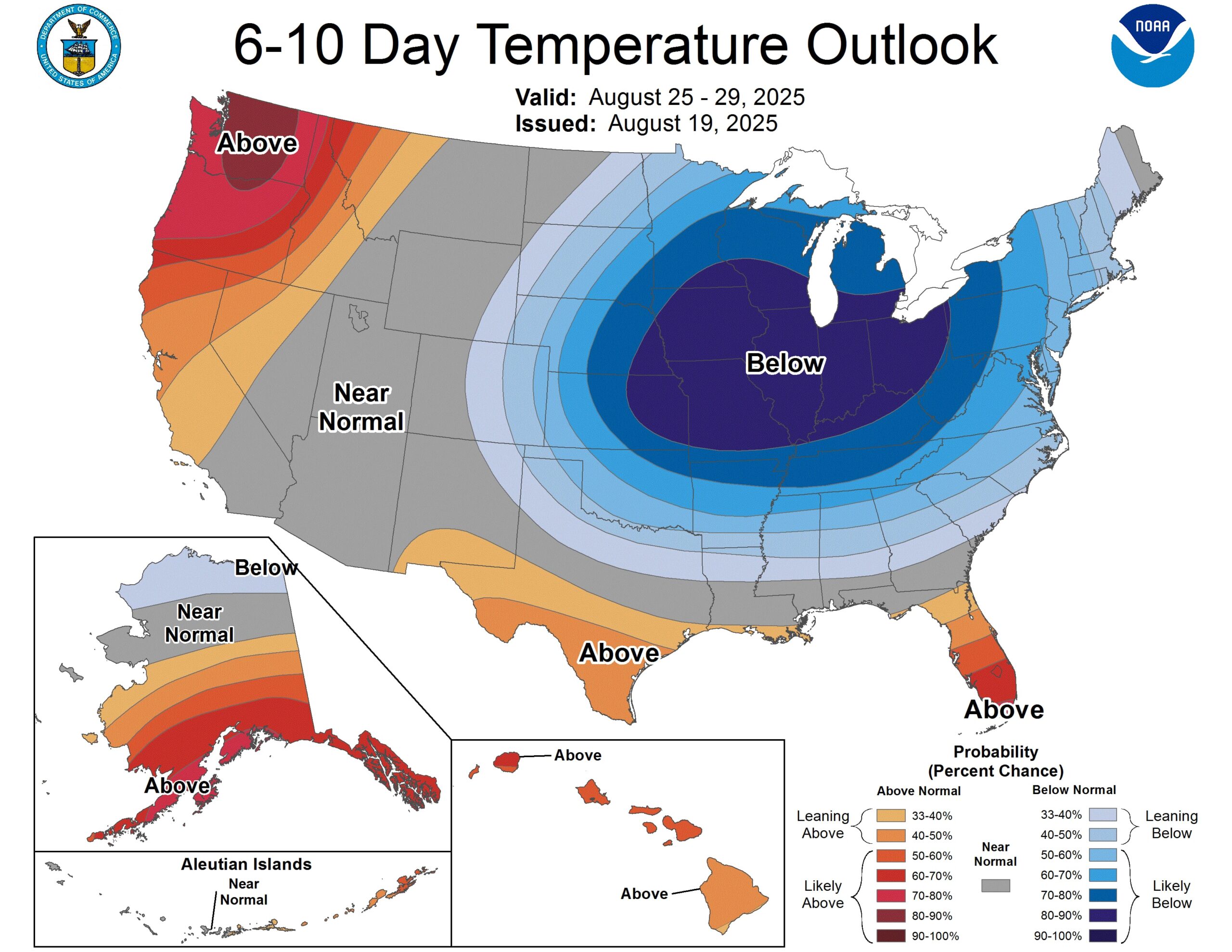
The Climate Prediction Center of NOAA concurs. According to its six- to 10-day temperature outlook, which is displayed at the top of this piece, the northernmost portion of the state has a 60–70% chance of experiencing below-average temperatures. The dates are August 25–29.
There is a 50–60% possibility of colder temperatures in the northern portion of central Alabama and the remainder of north Alabama.
South Alabama has a 33–40% likelihood of colder temperatures, while the remainder of central Alabama has a 40–50% possibility.
The exception is coastal Alabama, where temperatures are expected to be close to average.
Summer will return soon, so it’s not time to get out the jackets just yet, but it might be a pleasant change of pace from the usual August heat in Alabama.
In its forecast discussion on Wednesday morning, the National Weather Service in Birmingham stated that the models continue to promote the approach and probable passage of a cold front early next week, following a continuation of summery warmth and daily convection toward the end of the week and into the weekend.
We should witness a discernible drop in humidity levels and at least a few days of maximum temperatures that are at least 5–10 degrees lower than what we’ve been experiencing recently if this turns out to be true (and our confidence in that fact keeps growing).
However, high temperatures are expected to return to the mid-90s throughout much of the state today, making it another hot day. Rain and storms, including the possibility of isolated severe storms, are also more likely to occur today.
The forecast for Wednesday’s high temperature is as follows:
Over the next few days, temperatures in Alabama will gradually drop, with highs in north Alabama only predicted to reach the low 80s by the following week. Only the low 90s will be warmer in South Alabama.
The prediction for next Tuesday, August 26, is as follows:
The cold front is predicted by the weather service to pass over Alabama early next week.
Temperatures and humidity will drop as drier air moves into the state behind the front, according to the weather service.
Overnight temperatures in parts of north Alabama may reach the 50s, according to the Huntsville National Weather Service:
According to Huntsville forecasters on Wednesday, temperatures will gradually drop throughout the extended period, peaking in the mid 80s to lower 90s on Saturday and only dropping to the lower 80s on Tuesday.
It will truly feel like fall by Monday night, when lows will only be in the high 50s to lower 60s.