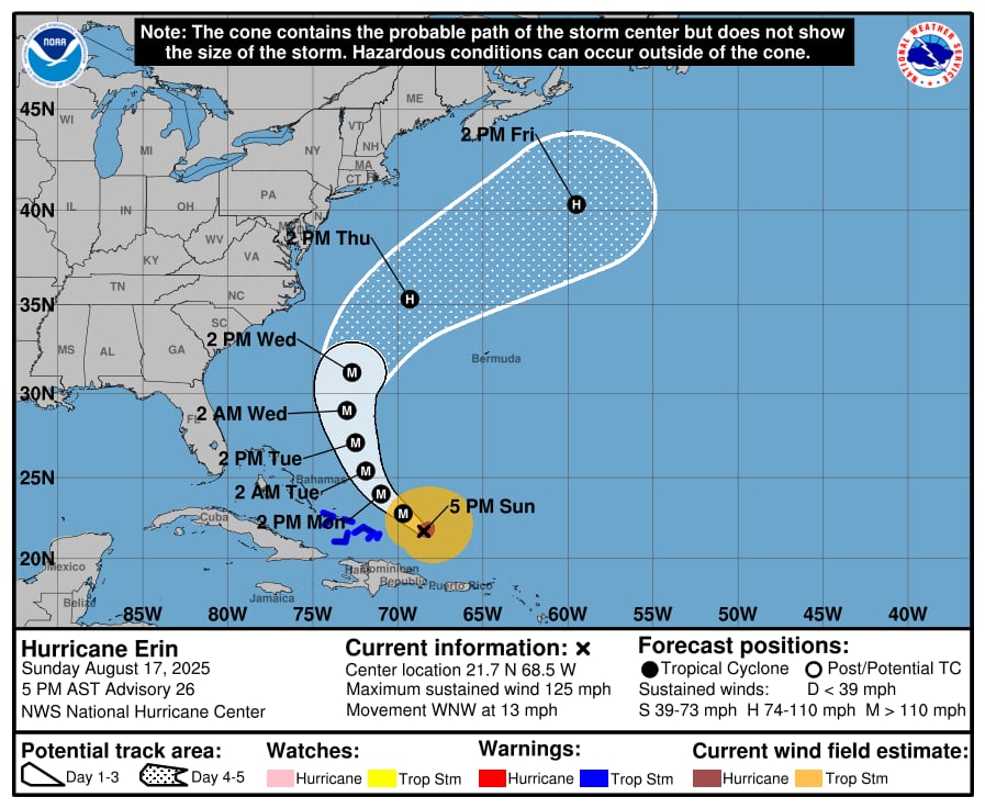
As to the National Hurricane Center, Hurricane Erin weakened on Sunday but remained a Category 3 storm with winds of 125 mph.
On Sunday afternoon, the first hurricane of 2025 in the Atlantic continued to move north of the Virgin Islands and Puerto Rico, bringing strong gusts and a lot of rain to those islands.
Later today, Erin is predicted to start to curve farther northward and leave the islands.
It will, however, travel near enough to the Bahamas that several of those islands are under a tropical storm warning.
Erin is predicted to increase in size and gain some strength during the coming days, the hurricane center added.
The hurricane center’s official prediction track directs it to go between the United States and Bermuda, away from the U.S. East Coast.
The hurricane center stated on Sunday that forecast models are divided on how close the storm will approach the U.S. East Coast.
For Days 3 and 4, the official predicted path has moved slightly to the west, and the hurricane center stated that future advisories may include some further forecast modifications.
Those heading north along the mid-Atlantic coast from North Carolina were advised by the hurricane center to monitor Erin since there is a chance of severe gusts linked to the outer rain bands in the middle of the week.
Beginning around midweek, Erin is also expected to increase the potential of dangerous rip currents and choppy surf throughout the whole East Coast.
At 4 p.m. CDT on Sunday, Hurricane Erin was traveling to the west-northwest at 13 mph, with its core roughly 275 miles northwest of San Juan, Puerto Rico.
Throughout the day, Erin has sustained winds of 125 mph, or Category 3 intensity.
Over the next two days, the hurricane center anticipates that Erin will acquire considerable strength and enlarge, and that it will continue to be a major hurricane until the middle of the week.
Erin rapidly intensified into a Category 5 storm on Saturday, reaching a maximum speed of 160 mph.
Although it is not anticipated to regain Category 5 power, the hurricane center believes Erin’s intensity may vary over the coming days.
Late Saturday and overnight, it underwent what the hurricane center described as structural changes that reduced its intensity but could ultimately result in the storm becoming larger.
As of Sunday afternoon, the southeastern Bahamas and the Turks and Caicos islands were under a tropical storm warning.
Although the hurricane center stated that tropical storm conditions were anticipated in the Turks and Caicos later today and tonight, as well as in the Southeast Bahamas tomorrow and Monday, Erin is predicted to pass east of those islands.
Puerto Rico and the central Bahamas may potentially get heavy rain and wind gusts up to tropical storm force today.
Flash flooding could occur in Puerto Rico and the Virgin Islands if Erin leaves behind 3 to 6 inches of rain.