The National Hurricane Center continued to monitor two other systems in the Atlantic on Saturday, but the former Hurricane Erin moved out to sea and turned into a non-tropical system on Friday.
Soon, one of them might turn into Tropical Storm Fernand.
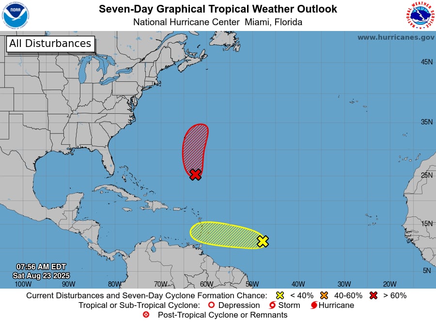
That system was roughly 500 miles southeast of Bermuda as of Saturday morning.
Later tonight, it may develop into a tropical depression, and on Sunday, it may intensify into Tropical Storm Fernand (pronounced fair-NAHN), according to the hurricane center.
Over the weekend, forecasters predicted that it would move northward and toward Bermuda.
An Air Force Reconnaissance plane is expected to look into the low this afternoon, according to the storm center.
According to the hurricane center, Bermuda could be under a tropical storm watch as early as today.
On Saturday, there was little likelihood that the second tropical disturbance would emerge.
On Saturday, it was roughly 850 miles east of the Windward Islands and was traveling at 20 mph westward.
On Sunday and Monday, the Windward Islands may have periods of intense precipitation.
Next week, the hurricane center anticipates that the system will shift into an unfavorable environment for Caribbean development.
On Saturday, there were no possible areas of concern in the Gulf, and none were anticipated in the days ahead.